 Warmer temperatures mean venomous reptiles leave their underground hide-outs in search of food and to mate. And nicer weather also means more people in parks and on trails. And that leads to more hospitals reporting an increase in rattlesnake bites, especially in California and Arizona. For those of us enduring our state’s shelter-in-place orders, the ability to get outside and get some exercise is crucial. But if that exercise involves going on a hike, or mountain biking on a rugged trail, there's another threat that we all need to aware of — snakes. According to herpetologists, there are four groups of venomous snakes in the United States: rattlesnakes, copperheads, cottonmouths/water moccasins and coral snakes. The best piece of advice when enjoying the great outdoors is “don’t be paranoid, be protected!" If you, too, want to escape the doldrums of the coronavirus "stay home, save lives" orders and get outside for some exercise and to soak up the sun, do it, but just be aware. After all, it is easy to social distance on most hiking trails, especially those in the back country. There are several things hikers can do to avoid danger between now and October when snakes are most active.
To avoid attracting rattlesnakes to your backyard and outbuildings, remove potential snake food and shelter from your property. Make sure you don’t have mice or rats and get rid of wood piles or garbage heaps that can make excellent hiding spots for snakes. If you are bitten by a snake, the Mayo Clinic advises: • Call 911 immediately or get yourself to a hospital as quickly as possible. • While waiting for medical help, stay calm and position the body so that the bite is at or below heart level. • Remove jewelry or tight clothing before swelling starts. • Do NOT apply ice or a tourniquet on or near the bite. • Do NOT cut the wound or attempt to suck out the venom. • Do NOT drink caffeine or alcohol, which could speed the body's absorption of venom. As reptiles, a snake’s body temperature mirrors air temperature, so it’s common to see many more snakes this time of year. Don’t avoid outdoor activities, but don’t take a chance either— protect yourself while in snake country by considering Razer Snake Gaiters. They will keep you safe while you enjoy the outdoors.
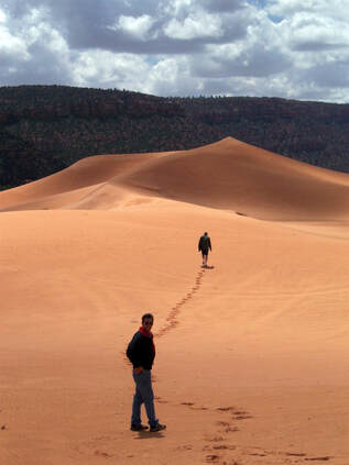
Most visitors stop at Coral Pink Sand Dunes State Park while touring Utah’s Grand Circle (Bryce Canyon and Zion, Arches, Canyonlands and Capitol Reef National Parks). Just 12 miles southwest of U.S. Hwy 89 near Kanab, the park is indeed convenient to these more popular attractions, but Coral Pink Sand Dunes is also a unique destination perched at an elevation of 6,000 feet. Photographers and off-road enthusiasts especially appreciate this unique landscape found nowhere else in the United States. The sweeping sandy expanse is 3,730 acres of contrasting color— coral dunes surrounded by red sandstone cliffs, blue skies, white fluffy clouds, and emerald junipers and pinion pines. The dunes are also a massive playground for riding off-highway vehicles! If you’d rather get around on your own two feet, hikers can get sand in their boots without dodging OHVs. Visit park website. Coral Pink Sand Dunes State Park is truly amazing!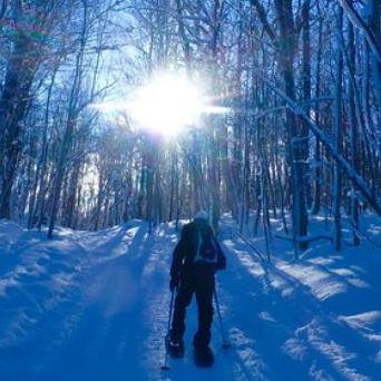 Looking for a way to stay in shape this winter? Snowshoeing is an excellent low-impact aerobic exercise that can burn 600 calories an hour, and is an excellent way to extend your hiking and running season. You also get to enjoy solitude in areas that might be crowded in summer. Snowshoeing is budget-friendly since it does not require expensive lift tickets or fancy gear. It’s also a great social activity that all ages and ability levels can enjoy together. If you can walk, you can snowshoe. As long as the snow depth is 6 or more inches, you’re good to go. If you’re just getting into snowshoeing, renting gear is a great way to get started. The rental shop will set you up with snowshoes suitable to your weight and the conditions where you’ll be snowshoeing. Make sure you check the maximum recommended load for your snowshoes (your weight plus the weight of your pack filled with gear should not exceed the recommended load) and take into consideration the type of snow you’ll be traveling on (freshly fallen powder requires snowshoes with a larger surface area to keep you floating on top of the snow). You may choose not to use poles, or only one pole when snowshoeing. It’s all personal preference. Poles help to maintain your balance while snowshoeing, especially on inclines and declines. They also provide support to help distribute your weight, which can protect your joints and muscles from injury. A good rental shop will help you to make sure your poles are adjusted correctly. You’ll want to dress layers when snowshoeing. As always when exercising outdoors, dress in layers so you can adjust your clothing to suit your activity level and the weather. Avoid cotton because when it gets wet, it stays wet. Instead, choose synthetics or wool because they wick moisture and retain warmth even when wet. Cross-country ski clothing is designed for aerobic winter activity, and can do double-duty as snowshoe clothing.
Walking on flat or rolling ground is fairly easy. Your stride should be wider than it is for hiking in order to avoid stepping on the insides of your snowshoe frames. Because of that, you may find your hips and groin muscles aching a bit after the first few times you snowshoe. Start slowly and plan for short routes. You can build up your level of adventure once you gain confidence and ability. It’s important to listen to your body and plan your snowshoeing adventure accordingly. As a beginner, there is no better way to begin snowshoeing than just going and doing it. At first, use your snowshoes to explore city parks or trails you are familiar with. As you become more experienced, check out the mountains outside of town, or far off backcountry areas filled with nothing but gorgeous scenery. Whether you snowshoe by yourself or with others who are also interested in maintaining or improving their cardiovascular fitness, always let someone know your route and plan in case of an emergency. Be aware of your surroundings, and come prepared with the appropriate gear and clothing. In no time you will enjoy being out and about amidst Old Man Winter!
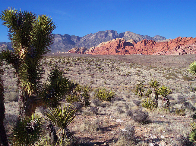
The one-way 13-mile scenic drive (open daily from 6:00 a.m. until dusk), offers numerous opportunities to picnic and photograph the beautiful shapes and colors up close. Stop first at the Visitor Center for a map, and while inside learn about the area’s geology, history, and wildlife, including the wild horses and burros you’re sure to see. It's hard to fathom, but Red Rock Canyon's natural desert beauty was once the bottom of an ocean. About 225 million years ago, movements of the earth's crust caused the seabed to slowly rise. When the seabed sediment was exposed to air, it began to oxidize, resulting in the red, pink, purple, and orange colored rocks seen today. It's also believed that millions of years ago two of the earth's plates collided, causing older layers of rock to be thrust horizontally over younger layers. The red sandstone collided with gray and tan limestone, creating striking multi-colored formations found in Red Rock Canyon. If you’re a rock climber, get your permit in advance. Red Rock Canyon National Conservation Area is one of the top five climbing destinations in the USA and has more than 2,000 routes. If you’d rather not get roped into anything, the beautiful colors and angles of the canyons, cliffs, and ravines are just as stunning from a hiking trail or roadside overlook. To see fragile petroglyphs (rock art carved into the surface of the rock), pictographs (painted onto the surface of the rock), and food roasting pits left behind by ancient Indians, be sure to hike the easy Willow Springs Loop trail. Trail Running Gaiters will keep sand out of your shoes. Razer Snake Gaiters are your best bet whenever you're in rattlesnake territory. There's quite a great deal to see and do beyond the opulent oasis of Las Vegas. Stock up on bottled water and prepare to be amazed by the colorful natural wonders just outside of town. Some areas are more colorful than the Strip!
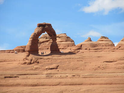
The best “don’t miss” stops within the park include Balanced Rock, the Windows, Delicate Arch, and Devils Garden (listed nearest to farthest away from the park entrance and visitor center). No matter how short your visit, drive at least as far as the Windows section. Parking lots at these popular destinations can overflow during peak season, so you may have to visit them in a different order. Scenic photo opportunities start immediately inside the park, so keep your camera handy. Just a couple of miles from the entrance and visitor center (stop here first for an overview of the park) are viewpoints for Park Avenue, Courthouse Towers, Three Gossips, and several other picturesque rock creations. Early explorers often named these remarkable formations after things or places from “back home.” For example, an early traveler from the Big Apple thought the skyscraper-like monoliths looked like New York’s Park Avenue, hence the name. If some of this scenery seems familiar, it could be that you recognize it from Hollywood movies such as Ten Who Dared, Indiana Jones and the Last Crusade, Thelma and Louise and others. About nine miles from the entrance to Arches National Park is aptly named Balanced Rock— a mammoth boulder balanced precariously on a pedestal. If you want to stretch your legs, a very short hiking trail takes you to the base of this 128-foot tall fragile formation. Or save your steps and snap a photo from the road. From Balanced Rock, a side road leads to the Windows area where three massive arches make perfect frames for the landscape beyond. North Window is the smallest opening with a span of 93 feet and a height of 51 feet. South Window is 105 feet long and 66 feet high. Turret Arch actually has two openings, the largest of which is 64 feet high and spans 39 feet. A one-mile trail leads right up to these stone spectacles. Delicate Arch is probably the most famous arch in the park—it’s the iconic symbol found on just about every book, brochure, and guide ever written about Arches National Park. It is 46 feet high with a width of about 35 feet. Although on the small side, this arch draws scores of photographers, so the area is usually very crowded. You can admire this arch from a wheelchair accessible viewpoint (Delicate Arch is about three-quarter miles in the distance), or stand in its shadow after trekking three miles over mostly slickrock. There’s not a bit of shade along the hard hike, so it can be brutal in the summer sun. Needless to say, take lots of water and slather on the sunscreen! If you choose the three-mile Delicate Arch Trail, it begins at the Wolf Ranch parking area. In the late 1800s, John Wesley Wolfe, a disabled Civil War veteran, and his son, Fred, built a homestead here. A weathered log cabin, root cellar, and corral are all that’s left of the primitive cattle ranch they operated for about a dozen years. Peek inside—the cabin is listed on the National Register of Historic Places. A panel of petroglyphs near the ranch is thought to have been carved by the Ute Indians some time between A.D. 1650 and 1850. Many of the figures show stylized riders on horseback, and animals that look like sheep. Located at the end of the road that runs through Arches National Park, Devils Garden is not only the name of the campground, but also the name of a trail from which you can see eight arches, many backdropped by the snow-capped La Sal Mountains. Getting the most out of this area definitely requires lacing up your hiking boots. The sandy Devils Garden Trail (wearing trail running gaiters will keep sand out of your shoes and keep your socks cleaner) leads to Landscape Arch, the longest in the park, measuring 306 feet from base to base. It stands 106 feet high and at its thinnest point is only 10 feet thick. In 1991, a massive slab of rock fell from its underside, resulting in an even thinner ribbon of rock. Additional rockfalls occurred in 1995 and 1996. Along the trail you’ll also pass Pine Tree Arch, Tunnel Arch, and more. Just before Devils Garden is a viewpoint and short trail to elegant Skyline Arch. Skyline is of particular interest because it’s so young. It formed in November 1940 when a major rockfall doubled the size of what was then called Arch-in-the-Making. Skyline spans 69 feet and is 45 feet high. Although the Beehive State is home to five national parks, seven national monuments, and numerous state parks and historic sites, Arches National Park is one of Utah’s literal highlights. Perched at elevations ranging from 4,085 to 5,653 feet above sea level, the landscape here is classified as a high desert. That means temperatures in the summer and winter can be extreme, so it’s best to visit in the spring or fall. No matter what season you visit, you’ll find the greatest density of natural arches on earth surrounded by 119 square miles of scenery just waiting to be explored. The only arches you won't find here are the golden arches!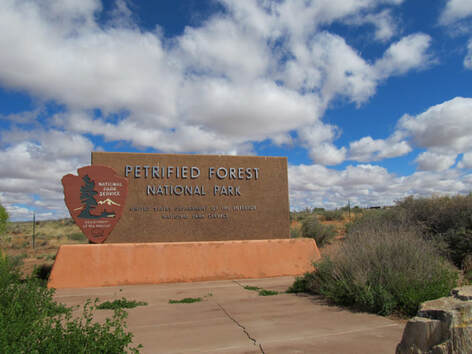 Given its name—Petrified Forest National Park—of course you would expect to find one of the world’s largest concentrations of wood that has turned to stone, but did you know that this northeastern Arizona park offers much more—ancient petroglyphs, pueblo ruins, dinosaur fossils, a national historic landmark, colorfully striated rock formations—and it is the only national park to protect a part of historic Route 66. That’s a lot of claims to fame! You can drive through the park in a couple of hours and admire the scenery through the windshield, or choose a developed hiking trail or two (remember your gaiters!) and get up close and personal with the park’s colorful past. So as not to miss any highlights, stop first at the Painted Desert Visitor Center as you enter the park from Interstate 40 and watch the 20-minute orientation movie. Or stop at the Rainbow Forest Museum if you enter the park from the south off Highway 180. Once armed with a visitor map and an understanding of this special place that became a national park in 1962, you’re set to take full advantage of the plentiful pull-offs and designated scenic stops. Don’t be surprised if the first question you are asked when inside the park is if you have any petrified wood already with you. Claim it if you do. Theft of this limited resource is taken very seriously by the park service. Flanking the 28-mile paved park road is arid Painted Desert scenery of mostly colorful sandstone and scrub. Depending on the time of day, you’ll see deep lavenders and rich grays, reds, oranges and pinks. The hues are especially brilliant at sunset. The Teepees and Blue Mesa loop drive are some of the prettiest clay and sandstone formations in the park. The Painted Desert and the Petrified Forest are really one in the same. They have the same rock layers, plants, animals, and fossils, but the Painted Desert is a vast landscape that stretches from here to Grand Canyon National Park. Even though it’s named the Painted Desert, it is hard to believe that the ecosystem here is not officially classified as desert. It's actually one of the largest areas of intact grassland in the Southwest. What’s even harder to believe as you look out over the seemingly barren dry terrain, is that during the Triassic Period 225 million years ago, 200-foot tall conifer trees grew along the banks of many streams and that giant amphibians, small dinosaurs, and lush ferns thrived here. Slowly but surely that tropical environment changed, but luckily much of the plant and animal life was fossilized during the process. As the stately trees fell into the swamplands, they were covered buried beneath layers of silt. Over time, chemical reactions occurred and tiny quartz crystals formed, encasing the wood and turning the trees to stone. In fact, petrified wood is so hard, you can only cut it with a diamond tipped saw! 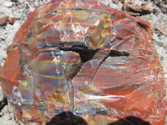 Thanks to millions of years of erosion and changes in the earth’s pressure, the logs once again saw the light of day, but in a completely different form—colorful petrified wood. The rainbow effects do not result from the type of wood, but from the chemistry of the petrifying groundwater. Iron oxides give petrified wood its red, yellow, and orange hues. Manganese oxides produce blues, purples, and deep blacks; the original carbon produces shades of gray. Just two miles down the road from the Painted Desert Visitor Center is the Painted Desert Inn National Historic Landmark. Built in 1924, the adobe-style structure doesn’t look like much from the outside, but it once served as a trading post and restaurant for travelers along historic Arizona Route 66. In the late 1930s, it was enlarged and extensively remodeled by the Civilian Conservation Corp, and features a blend of Spanish and Indian styles and designs. Look overhead in the Trading Post room to see hand-painted glass skylights based on ancient southwestern Indian pottery motifs, and hammered-tin chandeliers follow Mexican designs. The wall murals in the lunch room and dining room were painted in the late 1940s by Fred Kabotie, a Hopi Indian artist. The murals tie the ancestral Puebloan people of the region to the Hopi people of the 1940s and today. While Painted Desert Inn gained status as a National Historic Landmark primarily due to its architecture, the murals of Fred Kabotie made a significant impact on the nomination. 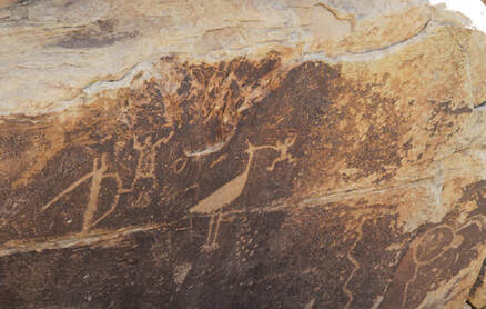 Don’t miss the park’s Puerco Pueblo ruins, where you’ll see evidence along an easy .3 mile loop trail of the Indians who lived in the area as early as A.D. 1100. Agate House at the south entrance of the park is another small pueblo you can see from a two-mile trail. Over 500 archeological sites lie scattered throughout Petrified Forest, but most are inaccessible in the backcountry. Puerco Pueblo may have been home to about 200 people and contained over 100 rooms. Archeologists say it used to be a one-story village built around a rectangular plaza. Without doors or windows in the exterior walls of the pueblo, entry into the village was by ladders over the exterior wall and across the log, brush, and mud roofs of the room blocks. Rooms around the plaza were used for storage and as living quarters. Within the plaza, three underground, rectangular kivas have been identified. It is thought that an extended drought around A.D. 1380 forced the inhabitants of Puerco to move elsewhere, leaving behind pottery fragments, stone tools, and petroglyphs (rock carvings). In addition to the glyphs along the south end of the Puerco Ruin Trail, Newspaper Rock has an unusually dense concentration of well-preserved mysterious carvings. Newspaper Rock must be admired from a distance (spotting scopes available at the viewpoint), whereas you get a much closer view of glyphs along the Puerco Ruin Trail. Desert varnish is a dark, thin coating of iron or manganese that slowly forms on the rock surface. Petroglyphs are made by chipping through this coating to reveal the lighter rock beneath. No one knows for sure what the symbols mean. Are they calendars, depictions of daily life, directions to something, or maybe just ancient graffiti? If you visit enough petroglyph sites throughout your travels, you’ll start to see patterns emerge— some of the same dots, squiggles, footprints, handprints, animal-like figures, and more appear repeatedly so perhaps they mean the same thing no matter their location. Crystal Forest, Giant Logs Trail, and the Long Logs Trail showcase the best and largest concentrations of petrified wood in the park. The petrification process preserved each tree a little differently, depending on the environmental conditions when it fell, so no two pieces are alike. Some of the logs look so real you’d think they were only recently cut down— the wood grain has been preserved in detail and the pieces are as symmetrical and sharp as those made by a saw blade. Other logs barely resemble wood at all, especially the prettier pieces. Some of the colors are so amazing you’d swear the logs were man-made and had never been a living tree. The Crystal Forest loop is paved and .75-mile long with interpretive signs along the way and a covered observation area. “Old Faithful” sits at the top of the Giant Logs Trail and is almost 10 feet across the base. The Giant Logs and Long Logs Trails are located at the Rainbow Forest Museum area at the very south end of the park. If you want to take home a little petrified wood as a souvenir, be sure to buy it at the gift shop. Removal of petrified wood (or any natural or cultural object) is strictly prohibited and punishable by federal law. You’ll be reminded of this over and over again on park signs and in brochures, but for good reason. Over the years, most of the petrified wood that was originally found in this area has been damaged or stolen. So unless Mother Nature reveals more through erosion, what you see now must remain for future visitors. At this park you can definitely see the forest for the trees! In 2018, a coalition of organizations working on global health and tropical medicine around the world, including Health Action International, launched the first-ever International Snakebite Awareness Day— September 19— to raise awareness of the huge, yet mostly unrecognized, global impact of snakebite. The launch of International Snakebite Awareness Day aims to raise awareness of the huge, yet mostly unrecognized, global impact of snakebite. The World Health Organization (WHO) estimates that between 81,000 and 138,000 people around the world die each year from snakebite and up to 400,000 are left permanently disabled or disfigured, as a result of being bitten by venomous snakes. Snakebites kill at least 40 times more people each year than land mines and leave at least 60 times more people with severe and permanent disabilities. In the United States, an average of 7,500 people are bitten each year. In 2017, the World Health Organization added snakebite envenoming to its list of highest priority Neglected Tropical Diseases (NTDs) and in May this year the 71st World Health Assembly unanimously adopted a resolution calling on the governments of the world and the WHO to tackle the problem. In some countries such as Central African Republic, it takes a monumental effort to get appropriate medical care to the communities who need it the most. Whether it’s because of cost, distance, or lack of trust in western medicine, rural communities in the global majority simply do not currently receive the proper medical care after a snakebite. It is estimated that only 2% of people bitten by venomous snakes in sub-Saharan Africa have access to quality antivenom treatment.To make matters even worse, it will take years to implement the necessary steps that will bring medical care to these communities, who desperately need it today. In the United States, snake bite victims are much luckier than in other countries because we have access to efficient medical care. Medicines known as antivenoms are the only effective treatment for snakebite. Quality anti venoms can prevent or reverse most of the effects caused by snake venom, saving lives. Until the day comes when all snakebite issues around the world have been solved, prevention is the first step in stopping this snakebite crisis. Being aware is a good thing. For example, the venom from a cottonmouth or copperhead rarely kills, although during the time spent recovering from the bite you might wish you were dead! The pain can be unbearable. Another particularly venomous species is the timber rattlesnake. Sometimes hikers are not sure that they have been bitten. A snake fang puncture might not go all the way through your shoe or pants even if you are struck. You might feel "something" and perhaps even glimpse "something" moving away through the weeds. You may not hear a rattle. But a pair of puncture marks at the wound is definitely a sign of a venomous snake bite, according to the U.S. Centers for Disease Control and Prevention (CDC). Symptoms of a bite can include redness or swelling, severe pain, nausea and vomiting, labored breathing, disturbed vision, increased salivation and sweating, and numbness or tingling in the face or limbs. The CDC says to seek medical attention immediately, to try to remember the snake's color and shape IF you see it, and to keep still and calm to slow the spread of any venom. While waiting on medical help, lie or sit down with the bite below the level of the heart, wash the bite with soap and water and cover it with a clean, dry dressing. It is not recommended to take steps such as applying a tourniquet or attempting to suck out the venom, according to the CDC. Prevention is always the safest and easiest route to avoid being bitten by a rattlesnake, so be proactive and wear snake gaiters whenever you are working or just having fun in snake country! A small price to pay for peace of mind. Although kids heading back to school and the calendar tells us that summer is officially winding down, encounters with snakes are not. Drought conditions, triple-digit temperatures, and other factors mean you still need to be very aware of the potential to see snakes, especially if you’re enjoying the outdoors in the late evening. Pit vipers such as Copperheads, Cottonmouths, and Rattlesnakes are not necessarily more active later in the day, you just might not see them as well now that the amount of sunlight each day is getting shorter, and the light is not as bright. When out in the evenings, carry a flashlight and watch where you put your hands and feet and watch where you sit down. Also avoid walking close to bushes or crevices with large holes. Reports of snake encounters have been particularly high in Texas and California. Texas is home to over 105 different species and subspecies of snakes; about 15 of those are potentially dangerous to humans. It seems that drought conditions, especially in the Golden State, result in an abundance of rattlesnakes. The California Fish and Wildlife Department reports that rattlers are coming up from their outback burrows and are sighted in backyards and parks much more often than ever before. Medical experts advise that if you are bitten by a snake, forget everything you learned from old Western movies— do NOT use a tourniquet, make an incision, or try to suck out the poison. A rattlesnake bite should be taken very seriously. Call 911 immediately or get to a medical facility! The faster you can get treatment, the better the outcome. The sooner you can get medical attention the sooner they can activate the system needed to get sufficient quantities of anti-venom to treat your bite. After that, the best but the hardest thing to do is try to remain calm. Avoid getting your heart rate up, which spreads the venom throughout your body faster. The same advice goes for pets if they are bitten. "The sooner the animal gets treatment, the more than likely it's going to survive," said a veterinarian in El Paso, Texas. “There is an antivenin available, but it’s extremely expensive. The effectiveness depends of the size of the dog and the amount of venom injected by the snake. A dose of antivenin for pets can cost more than $1,000." The cost of Crofab— the human antivenin— in some cases can cost more than $10,000! So no matter what the calendar might be telling us, keep in mind rattlesnakes are still in full force right now. They won’t go into hibernation in most areas for two or three more months. Whenever you’re out and about in snake country, or working in wooded areas or weeds, don't take a chance — wear snake gaiters. As with many things in life, prevention is your best bet.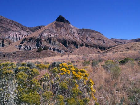 A trip to eastern Oregon’s John Day Fossil Beds National Monument is like visiting three parks in one. Divided into “units” — Sheep Rock, Clarno, and Painted Hills — and covering 14,000 acres, you’ll find each unit surprisingly distinct. The park itself is named for a river and not a man, but John Day was a real person who arrived in Oregon from Virginia in 1812. Mr. Day, however, is not known to have visited this area. As the park’s name implies, fossils are the focus here, and every summer the park's paleontology staff collects, identifies, prepares, and preserves rare fossil specimens found throughout the park. Scientists also collect soil and rock samples to better understand the ancient ecosystems and climates of eastern Oregon. As you look around at today’s near desert environment, it’s hard to believe that 50 million years ago crocodiles and palm trees flourished her. Sheep Rock Unit. The Sheep Rock Unit is named for the big horn sheep that live in the area, and a 1,100-foot high rock formation also bears the same name. The Thomas Condon Paleontology Center is the only visitor center at John Day Fossil Beds National Monument, so be sure to stop here. Located on Highway 19 between the towns of Dayville and Kimberly, it’s just two miles from the junction of Highway 26 and Highway 19. Named for an Oregon minister and self-trained scientist, Thomas Condon was the first person to identify the John Day fossil basin as a world-class paleontological area. Mr. Condon began excavating fossils here in 1865, and in recognition of his scientific successes, was appointed the first Oregon State Geologist in 1872. Today, the Paleontology Center displays hundreds of fossils, and corresponding wall murals depict what some of the ancient animals must have looked like. You can also watch paleontologists working in the lab, and a hands-on area makes learning especially fun for kids. One-quarter mile down the road from the Paleontology Center is the Cant Ranch Historical Museum. It serves as the monument headquarters and contains indoor and outdoor exhibits. James and Elizabeth Cant were Scottish immigrants who bought 700 acres in 1910, and built the house in 1917. In addition to raising four children, they raised wheat, alfalfa, and were sheep ranchers. The Cants were known to host many social events and often had house guests. The local schoolteacher even lived with the family and taught school in the third floor attic for a time. Photos and furnishings inside the house, and remnants of farm equipment outside, give you a good idea of how the Cant family lived. Clarno Unit. To reach the Clarno Unit of the John Day Fossil Beds National Monument, head 18 miles west of the town of Fossil along Oregon’s 286-mile Journey Through Time Scenic Byway. Although it’s a near-desert environment today, had you visited 44 million years ago, you would have seen a jungle-like landscape inhabited by tiny four-toed horses, huge rhino-like creatures, and crocodiles. Volcanoes would have towered in the background. The Palisades is the most striking feature in the 1,969-acre Clarno Unit and is a remnant of the ancient volcanoes. The spires were formed by volcanic mudflows called lahars. The red, buff, and beige layers are known as tuff (a rock formed of compacted volcanic fragments). The greenish rock contains celadonite, a mineral in high iron content. Each layer has a unique chemical composition and color, depending on the time of the various volcanic eruptions. For a closer look, stop at the Clarno Palisades picnic area. Three different quarter-mile hiking trails lead from here to the base of the cliffs. To see plant and nut fossils embedded in rocks, take the Trail of the Fossils. You won’t find dinosaur fossils here, though, because this part of the country was beneath the Pacific Ocean during the time of the dinosaurs. Petrified logs are visible in the cliff face of the Clarno Arch Trail, and interpretive signs along the Geologic Time Trail denote pre-historic events of the last 50 million years. Each foot of this trail represents 37,000 years! Keep in mind that you’re in rattlesnake country. If you see a snake, just back away slowly to let them know you mean no harm. But it's best to be on the safe side and wear snake gaiters— don't take a chance! Painted Hills Unit. Nine miles northwest of Mitchell, Oregon just off Highway 26, the aptly-named Painted Hills Unit of John Day Fossil Beds National Monument is over 3,000 acres of scenic beauty. If you enjoy wildflowers— pink prairie clover, purple penstemon, yellow bells, white bitterroot, and many others—the best time to visit is late April or early May. But even if you miss peak bloom season, the vividly-hued layers of volcanic ash are amazing year-round. Contrasted by green sagebrush, the red, gold, beige, and black hummocks make for great photos, and the changing light and moisture content ensures these hills never look the same way twice. The unique colors of the Painted Hills were formed by volcanic eruptions that sent clouds of ash over much of Central Oregon. Over time, layers of ash formed with different minerals, which led to the bands of color seen today. As the climate here changed, the layers of ash were covered by water and formed the bottom of a lakebed. After millennia, the lake eventually dried up, allowing wind and rain to erode and carve it into mounds. The black soil comes from the vegetation that once grew on the edge of the lake, and the red coloring attests to the fact that the area was once warm and humid. After exposure to air and water, the minerals in the volcanic ash oxidized and transformed into a kaleidoscope of claystone. Although there are several trails, hikers should not walk on the Painted Hills themselves. The clay is very susceptible to erosion and damage. Stick to the boardwalk on the Painted Cove Trail, and to designated dirt trails elsewhere. Gaiters for hiking will help with the dust, but it's best to wear Snake Gaiters when wandering anywhere in Oregon's high desert areas. Keep safe and enjoy the outdoors!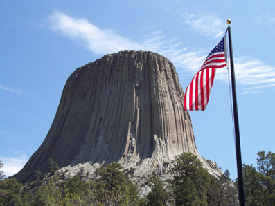 Seeing that famous tower shape jutting into the northeastern Wyoming sky, you can’t help but remember the 1977 sci-fi film Close Encounters of the Third Kind. But as soon as you start hiking the trails around Devils Tower National Monument, thoughts of alien spaceships are quickly forgotten. The distinctive 867-foot monolith and surrounding scenic countryside easily capture your attention without the help of Hollywood. Located where the pine forests of the Black Hills meet the rolling prairie grasslands and meandering Belle Fourche River, the monument’s proper name is actually Devils Tower, not Devil’s Tower (a clerical error on early governmental paperwork mistakenly omitted the apostrophe). The name was derived from the Native Americans who referred to it as "the bad god's tower." Believing that "the devil’s tower" was a better English translation, US Army Colonel Richard Dodge recorded it as such in his journal and official documents while escorting a scientific team into the Black Hills region in 1875. Long before then, however, Northern Plains Indian tribes called their sacred worship site Mateo Teepee (Bear Lodge). Some Indian tribes prefer that the tower and the region still be called Bear Lodge, which is consistent with the legend of its creation. According to one story, a giant bear tried to attack seven girls while they were playing in the area. The girls climbed onto a rock and begged the Great Spirit for rescue from the bear. The rock then rose upward, carrying the girls to safety while the bear clawed at the sides of the rock, leaving the hundreds of deep vertical furrows that you see today. Hollywood might lead us to believe that Devils Tower was created as a landing platform for extraterrestrials, but geologists have more plausible theories. Some think it is an eroded remnant of a laccolith, a mass of igneous rock that pushed through sedimentary rock but did not actually reach the surface and instead produced a rounded bulge. Other scientists speculate it might be the neck of a small volcano. No one has a definite answer as to how Devils Tower was exactly formed, but perhaps it’s the mystery that makes the Monument even more interesting. Several trails take hikers up close to the unique rock formation, but the 5,000 or so hard-core climbers who scale its challenging walls each summer achieve a much loftier perspective. Wondering what it’s like at the top? The peak is covered in sagebrush and grass and provides an all-encompassing view from 5,112 feet above sea level! If you’d rather not get roped into anything yourself, just take binoculars along on the paved 1.3-mile loop Tower Trail and live a little vicariously. The mostly shaded peaceful trail encircles the base of the tower and provides good views of climbers clinging precipitously to the rock face. Interpretive exhibits and benches along the way make this a most popular trail. For those seeking a more traditional hiking experience, strap on Razer Hiking Gaiters to protect your pants and legs, and hit the 2.8-mile loop Red Beds Trail that will offer great views of the Tower and surrounding Belle Fourche River valley. Along the north boundary of the park is a 1.5-mile loop trail that follows Joyner Ridge and dips down into the draw below the ridge. One of the more scenic but less utilized trails in the park, Joyner Ridge Trail provides beautiful views of the Tower, especially around sunset. A half-mile connector trail links Joyner Ridge with Red Beds. Maps and additional hiking trail information is available at the Visitor Center. If you like wildlife on the small side, you won’t be disappointed. A colony of lively black-tailed prairie dogs can be seen right from the main road. Their burrows are elaborate underground networks of interconnecting tunnels with multiple entrance holes, so they literally pop up all over the place! Named for their bark-like calls that sound more like high-pitched squeaks, the entertaining little prairie dogs really aren’t dogs at all. They are rodents closely related to ground squirrels and chipmunks. Wild turkeys, deer, rabbits, many species of birds, and porcupines also inhabit Devils Tower National Monument. Sorry, no little green men have been spotted since Steven Spielberg and his film crew cleared out 40+ years ago! Devils Tower has also made history outside of the movies. In September 1906, President Theodore Roosevelt established the rock formation and surrounding 1,347 acres as America’s very first national monument. The major difference between a national park and a national monument is that a national park encompasses a large land or water area that contains a variety of resources, whereas a national monument is smaller and usually preserves just one significant resource. Although it lacks national park status, Devils Tower National Monument is no less impressive and interesting, as any of its 400,000 annual visitors will tell you. But don’t take their word for it. Plan your own encounter with the remarkable topography, history, geology, and legends of northeastern Wyoming’s most conspicuous landmark. FOR MORE INFORMATION: Devils Tower National Monument Devil's Tower - It's out of this world! |
RAZER GAITERS
 RSS Feed
SNAKE GAITERS SNOW GAITERS TRAIL RUNNING GAITERS HIKING GAITERS NECK GAITER / FACE MASK CANVAS TOOL BAGS
|
Company Mission: To provide the best quality gaiters that keep you safe and comfortable on all your outdoor adventures.
Copyright ©2018-2024 |
|